Authorized Main Dealer

Kamis, 29 Oktober 2015

Terima Unlock (Buka kunci) simcard Inmarsat Isatphone Pro satellite phone

Bagi anda yang memiliki HP/Telepon satellite Inmarsat Isatphone pro produksi atau keluaran Distributor tertentu
biasanya unit tersebut dilock atau terkunci dan hanya bisa menggunakan kartu simcard dan isi ulang ditempat asal pembelian produk. 
Tanda bahwa HP inmarsat anda dilock adalah ketika dimasukkan simcard dari provider lain (misal singtel / AST) tidak akan terbaca oleh pengkat Inmarsat anda. Yang muncul adalah tulisan "Corporate Restriction" di layar. 
Hal tersebut terjadi karena unit inmarsat anda dilock, jika anda ingin mengganti provider kartu sebelumnya dengan provider lain, maka anda harus membuka Lock tsb agar unit anda bisa menggunakan kartu dari provider lain. 

Mengapa harus di unlock? 
- Untuk memudahkan anda melakukan isi ulang pulsa, jika toko/dealer tempat anda beli HP satelit tutup
  Atau mungkin harga pulsa terlalu mahal dan proses isi ulang lama. 
- Untuk memudahkan anda mengganti kartu jika sewaktu-waktu simcard anda Expired dan toko/dealer tempat anda beli kartu tutup atau stok tidak tersedia. 
  Karena masa aktif kartu hanya 6 bulan dari tanggal aktivasi atau tanggal isi ulang pulsa.

Kami dapat membantu anda untuk Unlock atau membuka kunci tersebut, agar anda dapat menggunakan kartu simcard dari provider lain. 
dengan catatan kartu lama (atau kartu bawaan msh ada). karena hal ini dibutuhkan untuk unlock HP inmarsat anda. 
Biaya unlock Rp.500.000,- /unit

Dan jika anda mendapati perangkat inmarsat anda susah untuk terkoneksi ke satellite, atau muncul tulisan "Limited Service" atau "The simcard is not provided, Please contac your service provider" cek versi software inmarsat anda, apakah sudah update ke software yg terbaru. Jika belum update maka anda harus melakukan update software untuk bisa menggunakan perangkat anda kembali. karena software yg lama sudah tidak bisa lagi terkoneksi ke satellite Inmarsat di angkasa. 
Dan untuk solusi hal tsb. kami juga dapat membantu anda untuk update ke sofware yg baru. 
Biaya update software Rp.500.000,- / unit

Dan bagi anda yang ingin membeli kartu simcard baru provider AST/Singtel juga tersedia ditempat kami. 
Untuk AST isi ulang lebih mudah dan cepat, karena kami mempunyai system pengisian pulsa sendiri tanpa harus request ke provider dan menunggu lama. 
Sedangkan untuk Singtel pulsa akan kami proses max 1x24 Jam


For update & Information :
0813 1224 5740 
0856 9239 9740 
Terry Alessandro  


Selasa, 20 Oktober 2015

Jual/Jasa/Terima Update Peta (Map) City Navigator Indonesia NT.2016.40 GPS Garmin Nuvi 1460, 1250, 1350, 2565LM, 40LM, 50LM, 65LM DLL Release date 2017

Garmin City Navigator Indonesia NT.2016.40 for Nuvi all type's
Stretmaps for your Navigation.
Rp. 500.000,- (Include Micro SD card & free ongkir) 

Jual/Jasa/Update Peta GPS Garmin
Update terbaru peta Indonesia tahun 2017 telah diperbaharui, jika sebelumnya jalan tol Cikampek - Palimanan belum ada, kali ini update Tol Cipali sudah ada dalam peta versi ini. anda sudah dapat menikmati perjalanan ke pulau jawa tanpa tersesat dan lebih cepat.

Bagi anda yang memiliki GPS Navigasi mobil merk Garmin Nuvi dan ingin mendapatkan peta jalan update terbaru di Indonesia atau navigasi untuk negara2 diluar negeri, kami dapat membantu anda untuk instal peta Pada GPS Garmin anda.
Update Terbaru City Navigator Indonesia NT.2016.40, POI lebih detail dan lengkap
Peta Garmin City Navigator ini khusus untuk GPS Merk Garmin, update terbaru dan terlengkap tahun 2017.
Pemasangan sangat mudah sekali:
Paket pembelian peta terdapat dalam memory card ( Micro SD)
Anda hanya tinggal memasangkan saja pada slot memory card GPS anda,
Maka peta Garmin City Navigator sudah dapat terbaca otomatis oleh perangkat GPS Nuvi anda.
Lihat peta yg terinstal pada pengaturan/seting - Map - Map info

Contain :
- Micro SD card 8GB
- Map City Navigator Indonesia


Coverage area peta ini Meliputi kawasan seluruh Indonesia (Full Coverage)
POI lengkap, dan informasi nama jalan2 dan tempat2 penting, seperti :
- Kantor polisi terdekat
- Restoran
- Tempat Hiburan
- Tempat ATM
- Tempat perbelanjaan (mall)
- Pengisian bahan bakar SPBU terdekat
- Ataupun tempat2 umum yang ingin anda kunjungi
- DLL, Semua POI ( point of interest) lengkap

Sangat efektif dan sangat membantu anda dalam pencarian alamat, terutama pada wilayah yang belum anda ketahui.
Dapatkan Update terbaru dan terlengkap hanya disini.

Update Peta yang tersedia antara lain :
- Peta Navigasi Indonesia (versi terbaru)
- Garmin City Navigator Indonesia 2016.40 release date 2017
- Garmin City Navigator Full Europe update 2018.10
- Garmin City Navigator UK (inggris) & Ireland 2017
- Garmin City Navigator Canada 2017
- Garmin City Navigator Nort America full 2018.10
- Garmin City Navigator Australia & New Zealand 2018.10
- Garmin City Navigator Malaysia, Singapore, Bruney, Filipina
- Garmin City Navigator Japan
- Garmin City Navigator Africa-South-East Asia
- Garmin City Navigator Italia & Greece (Yunani)
- Garmin City Navigator Germany
- Garmin City Navigator Middle East & Africa
- Garmin City Navigator Turkey 2017
- DLL


Paket Pembelian sudah termasuk micro SD card 8GB sesuai kebutuhan GPS masing-masing.
Bagi yang tidak ingin menunggu lama pengiriman, bisa melakukan Transaksi COD disekitaran Jakarta Barat. atau sesuai kesepakatan.
Dan untuk anda yang berada diluar kota dapat melakukan pembelian via transfer, dan barang akan kami kirim via JNE. (harga sudah termasuk ongkos kirim)

For update & information :
Terry Alessandro 
0813 1224 5740 (Call & WA)
0856 9239 9740 


Minggu, 11 Oktober 2015

Jual Garmin GPS Map 64S Generasi terbaru pengganti 62S Harga terjangkau

Garmin GPS Map 64S

Termasuk kelengkapan standard
- Units GPS
- Gantungan pinggang
- USB cabel data
- Manual book
- Upload peta indonesia terbaru
- Warranty card

Physical & Performance
Physical dimensions 2.4" x 6.3" x 1.4" (6.1 x 16.0 x 3.6 cm)
Display size, WxH 1.43" x 2.15" (3.6 x 5.5 cm); 2.6" diag (6.6 cm)
Display resolution, WxH 160 x 240 pixels
Display type transflective, 65-K color TFT, transflective
Weight 8.1 oz (230 g) with batteries
Battery 2 AA batteries (not included); NiMH or Lithium recommended
Battery life 16 hours
Water rating IPX7
High-sensitivity receiver
Interface high-speed USB and NMEA 0183 compatible
Barometric altimeter
Electronic compass Yes (tilt-compensated 3-axis)
Unit-to-unit transfer (shares data wirelessly with similar units)

Maps & Memory
Basemap
Ability to add maps
Built-in memory 4GB
Accepts data cards microSD™ card (not included)
Custom POIs (ability to add additional points of interest)
Waypoints/favorites/locations 5000
Routes 200
Track log 10,000 points, 200 saved tracks

Outdoor Features
Automatic routing (turn by turn routing on roads) Yes (with optional mapping for detailed roads)
Geocaching-friendly Yes (Paperless)
Custom maps compatible
Hunt/fish calendar

Sun and moon information
Tide tables Yes (with optional Bluechart)
Area calculation
Picture viewer
Garmin Connect™
Garmin Connect™ compatible (online community where you analyze, categorize and share data)
Additional
Additional
Smart Notifications: yes

Live Tracking: yes (with Garmin Connect™ Mobile)


For Update & information : 
 0856 9239 9740 
 0813 1224 5740
 cp: Alessandro Terry 

Selasa, 06 Oktober 2015

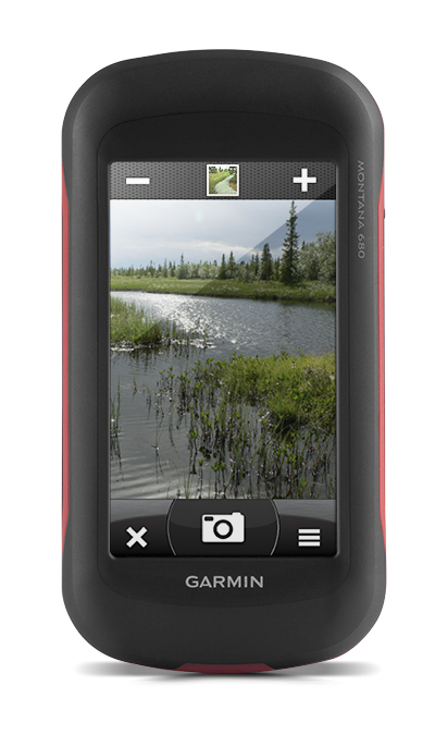
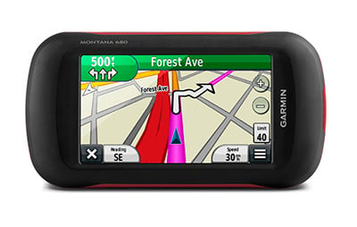
Jual Garmin GPS Montana 680 new 2017 Free Peta Topografi Indonesia

New Garmin Montana 680
Generasi pengganti Garmin Montana 650

Garansi Produk 1 Tahun
Kelengkapan standard, Free Peta Topografi & Navigasi Indonesia.

For order & Information:
0813 1224 5740
0856 9239 9740
Terry Alessandro


Rugged GPS/GLONASS with 8 Megapixel Camera and BirdsEye Subscription

  • 4-inch dual-orientation, glove-friendly touchscreen display
  • 8 megapixel autofocus camera; automatically geotags photos
  • Tracks both GPS and GLONASS satellites
  • 1-year BirdsEye Satellite Imagery subscription
  • 3-axis compass with barometric altimeter

Take it hiking. Take it hunting. Take it on the water.

Montana 680 features a dual-orientation, color touchscreen that’s glove friendly and includes a 1-yearBirdsEye Satellite Imagery subscription. The digital camera provides high-quality images, excellent resolution and automatically geotags photos with coordinates.
Handheld includes 3-axis tilt-compensated compass, barometric altimeter and access to both GPS and GLONASS satellites for improved positioning and typically faster fixes.

Enjoy the View

Montana 680 has a vast 4-inch, sunlight-readable touchscreen display, giving you vivid colors and high-resolution images. Its easy-to-use touchscreen means you’ll spend more time enjoying the outdoors and less time searching for information.

Take Geotagged Pictures

Capture locations and memories with Montana 680’s 8 megapixel digital camera. Each photo is automatically geotagged with coordinates, allowing you to navigate back to that exact spot in the future. Keep track of your photos and see their locations on a map using BaseCamp™. Insert a microSD™ card for more photo storage or to view pictures from other devices.

Mount Anywhere

With an array of compatible mounts, Montana 680 is designed for use on ATVs, in boats, as a handheld or in your car or RV. Use the auto mount with City Navigator® NT maps for spoken, turn-by-turn driving directions or the rugged mount for your motorcycle or ATV.

Go Everywhere

Adding more maps to Montana is easy. DownloadTOPO U.S. 24K maps and hit the trail, plug inBlueChart® g2 preloaded cards for a day on the water or load City Navigator map data for turn-by-turn driving directions. Add satellite images to your maps with BirdsEye Satellite Imagery (1-year subscription included). Or, transform paper maps into files you can download to your Montana with Custom Maps.

Share Wirelessly

With Montana 680, you can share your waypoints, tracks, routes and geocaches wirelessly with other compatible Garmin GPS users. Just press “send” to transfer your information to similar devices and let the games begin.

Keep Your Fix

With its high-sensitivity GPS and GLONASS reception, WAAS-enabled receiver and HotFix® satellite prediction, Montana 680 locates your position quickly and precisely and maintains it. Whether you’re in deep woods or just near tall buildings and trees, you can count on Montana 680.

Navigate with Ease

Montana 680 has a built-in 3-axis tilt-compensated electronic compass, which shows your heading even while you’re on the move or not holding it level. The barometric altimeter tracks changes in pressure to pinpoint your precise altitude, or use it to plot barometric pressure over time to help keep an eye on changing weather conditions.

Double Your Power

With a one-of-a-kind dual battery system, the 680 gives you the option of using the rechargeable lithium-ion pack or traditional AA batteries.

Find Fun

Montana 680 supports paperless geocaching GPX files for straight-to-device uploading of geocaches from Geocaching.com. No more manually entering coordinates and paper print outs, Montana stores and displays key information, including location, terrain, difficulty, hints and descriptions. The track manager feature helps organize and navigate through waypoints/routes/ and track logs (easily start/stop recording tracklogs).

Plan Your Next Trip

Our free BaseCamp software lets you view and organize maps, waypoints, routes and tracks. This free trip-planning software even allows you to create Garmin Adventures that you can share with friends, family or fellow explorers. BaseCamp displays topographic map data in 2-D or 3-D on your computer screen, including contour lines and elevation profiles.

Physical & Performance

Physical dimensions2.9" x 5.7" x 1.4" (7.48 x 14.42 x 3.64 cm)
Display size, WxH2"W x 3.5"H (5.06 x 8.93 cm); 4" diag (10.2 cm)
Display resolution, WxH272 x 480 pixels
Display typebright, transflective 65k color TFT, dual-orientation touchscreen; sunlight readable
Touchscreen
Weight10.2 oz (289 g) with included lithium-ion battery pack; 11.7 oz (333 g) with 3 AA batteries (not included)
Batteryrechargeable lithium-ion (included) or 3 AA batteries (not included); NiMH or Lithium recommended
Battery lifeup to 16 hours (lithium-ion); up to 22 hours (AA batteries)
Water ratingIPX7
High-sensitivity receiver
Interfacehigh-speed USB and NMEA 0183 compatible
Camera
yes (8 megapixel with autofocus; automatic geo-tagging)
Barometric altimeter
Electronic compassYes (tilt-compensated 3-axis)
Unit-to-unit transfer (shares data wirelessly with similar units)

Maps & Memory

Basemap
Ability to add maps
Built-in memory4 GB
Accepts data cardsmicroSD™ card (not included)
Custom POIs (ability to add additional points of interest)
Waypoints/favorites/locations4000
Routes200
Track log10,000 points, 200 saved tracks

Outdoor Features

Automatic routing (turn by turn routing on roads)Yes (with optional mapping for detailed roads)
Geocaching-friendlyYes (Paperless)
Custom maps compatible
Hunt/fish calendar
Sun and moon information
Tide tablesYes (with optional Bluechart)
Area calculation
Picture viewer

Garmin Connect™

Garmin Connect™ compatible (online community where you analyze, categorize and share data)

For order & Information:
0813 1224 5740
0856 9239 9740
Terry Alessandro


Jual Garmin Etrex 30X Terbaru dari garmin 2017 free Peta Indonesia

Garmin GPS Etrex 30x Sebagai pengganti ETrex 30
Fitur lebih unggul dan bagus, Garansi produk 1 Tahun
Kelengkapan standard

Spesifikasi sbb:

Handheld GPS, 3-axis Compass: Better Resolution and Memory

  • Greater resolution with 240 x 320 display pixels for improved readability
  • Internal memory expanded to hold more maps
  • Worldwide basemap with shaded relief
  • 2.2-inch, 65K color, sunlight-readable display
  • 3-axis compass and barometric altimeter
eTrex 30x is our upgraded version of the popular eTrex 30, with enhanced screen resolution for a more readable display and internal memory expanded to hold more maps. It retains the ease-of-use, durability and affordability that eTrex is legendary for and can also be used on ATVs, bicycles, boats, cars or hot air balloons.

See the Way

eTrex 30x has an enhanced 2.2-inch, 65K color, sunlight-readable display. Durable and waterproof, eTrex 30x is built to withstand the elements. It has an upgraded interface yet retains its legendary toughness to withstand dust, dirt, humidity or water.

New Tools for Your Trek

eTrex 30x adds a built-in 3-axis tilt-compensated electronic compass, which shows your heading even when you’re standing still, without holding it level. Also added is a barometric altimeter which tracks changes in pressure to pinpoint your precise altitude, and you even can use it to plot barometric pressure over time, which can help you keep an eye on changing weather conditions.

Go Anywhere

With an array of compatible mounts, eTrex 30x is designed as a handheld or for use on ATVs, bicycles, in boats, cars even hot air balloons. Use the auto mount capability and City Navigator NT® maps for turn-by-turn driving directions, or the rugged mount for your motorcycle or ATV. Wherever you think you might take eTrex, it has the mapping and mounts to get you there.

Go Global

The eTrex series is the first-ever consumer-grade receivers that can track both GPS and GLONASS satellites simultaneously. When using GLONASS satellites, a system developed by the Russian Federation, the time it takes for the receiver to “lock on” to a position is (on average) approximately 20 percent faster than using GPS. And when using both GPS and GLONASS, the receiver has the ability to lock on to 24 more satellites than using GPS alone.

Add Maps

With its microSD™ card slot and expanded 3.7 GB of internal memory, eTrex 30x lets you load TOPO 24K orGarmin HuntView™ maps and hit the trail, plug in BlueChart® g2 preloaded cards for a great day on the water or City Navigator NT map data for turn-by-turn routing on roads. eTrex 30x also supports BirdsEye Satellite Imagery (subscription required), that lets you download satellite images to your device and integrate them with your maps.

Share Wirelessly


Wirelessly connecting to a variety of compatible Garmin devices, including VIRB™ action cameras and ANT+® sensors (including heart rate monitor and bike cadence), the eTrex 30x can also read from and write to the chirp™ wireless beacon — or link with your trail buddy’s Oregon®, Montana®, GPSMAP® 64 or other ANT+-enabled outdoor navigation devices.

Keep Your Fix

With its high-sensitivity, WAAS-enabled GPS receiver and HotFix satellite prediction, eTrex locates your position quickly and precisely and maintains its GPS location even in heavy cover and deep canyons.

Find Fun

eTrex 30x supports geocaching GPX files for downloading geocaches and details straight to your unit. VisitGeocaching.com to start your geocaching adventure. By going paperless, you're not only helping the environment but also improving efficiency. eTrex 30x stores and displays key information, including location, terrain, difficulty, hints and descriptions, which means no more manually entering coordinates and paper printouts. Simply upload the GPX file to your unit and start hunting for caches.

Plan Your Next Trip

Take charge of your next adventure with BaseCamp™, software that lets you view and organize maps, waypoints, routes, and tracks. This free trip-planning software even allows you to create Garmin Adventuresthat you can share with friends, family or fellow explorers. BaseCamp displays topographic map data in 2-D or 3-D on your computer screen, including contour lines and elevation profiles. It also can transfer an unlimited amount of satellite images to your device when paired with a BirdsEye Satellite Imagery subscription.

Physical & Performance

Physical dimensions2.1" x 4.0" x 1.3" (5.4 x 10.3 x 3.3 cm)
Display size, WxH1.4" x 1.7" (3.5 x 4.4 cm); 2.2" diag (5.6 cm)
Display resolution, WxH240 x 320 pixels
Display type2.2" transflective, 65K color TFT
Weight5 oz (141.7 g) with batteries
Battery2 AA batteries (not included); NiMH or Lithium recommended
Battery life25 hours
Water ratingIPX7
High-sensitivity receiver
InterfaceUSB
Barometric altimeter
Electronic compass
Unit-to-unit transfer (shares data wirelessly with similar units)

Maps & Memory

Basemap
Ability to add maps
Built-in memory3.7GB
Accepts data cardsmicroSD™ card (not included)
Custom POIs (ability to add additional points of interest)
Waypoints/favorites/locations2000
Routes200
Track log10,000 points, 200 saved tracks

Outdoor Features

Automatic routing (turn by turn routing on roads)Yes (with optional mapping for detailed roads)
Geocaching-friendlyYes (Paperless)
Custom maps compatible
Sun and moon information
Tide tablesYes (with optional Bluechart)
Area calculation
Picture viewer
in The box:
  • eTrex 30x
  • USB cable
  • Documentation


For order & Informastion:
0813 1224 5740
0856 9239 9740
Terry Alessandro